SG crestA Singapore Government Agency WebsiteHow to identify
Official website links end with .gov.sg

Government agencies communicate via .gov.sg websites (e.g. go.gov.sg/open). Trusted websites

Secure websites use HTTPS

Look for a lock () or https:// as an added precaution. Share sensitive information only on official, secure websites.

About our parks, nature reserves and park connectors

Learn more about our thriving green spaces in Singapore and the networks of ecological corridors that link them to bring plants, wildlife and people together.

Singapore is one of the greenest cities in the world. After 6 decades of greening efforts, we now have a thriving network of green spaces where nature is entwined into our everyday lives.

About nature corridors

Nature corridors are pathways that map out important ecological connections between areas that are rich in biodiversity, such as nature reserves and nature parks.

How they are developed

Each nature corridor is developed by studying the ecological profile of the area and its connectivity with surrounding habitats. Ecological connectivity is then enhanced by creating new connections between existing parks, nature ways and the park connector network while safeguarding existing ones.

The Bukit Batok Nature Corridor lies between Bukit Timah Nature Reserve and the Tengah Forest Corridor.

The hills within this nature corridor allow the movement of wildlife and facilitate the exchange of genetic material between the two areas for healthier populations.

How connectivity is enhanced

Two upcoming nature parks, the 9-hectare Bukit Batok Hillside Nature Park and the 16-hectare Bukit Batok Central Nature Park, have been safeguarded. These areas will be protected to strengthen the connectivity between the Central Nature Park Network and Tengah Forest Corridor.

Altogether, the Bukit Batok Nature Corridor will comprise more than 125 hectares of nature parks and 10km of trails that will serve as ecological connectors, as well as nature ways and park connectors.

The Clementi Nature Corridor comprises forested sites at Clementi, Toh Tuck and Maju as well as the Rail Corridor.

It provides ecological connectivity between Bukit Timah Nature Reserve and the Southern Ridges, and also links up the Bukit Batok Nature Corridor with the Labrador Nature Park Network.

How connectivity is enhanced

Connectivity routes are continuously being identified while planning land use within the Clementi Nature Corridor. This will allow ecological connectivity in the area to be maintained, even with future developments.

In addition, a sizeable nature park will be safeguarded on the western side of the greenfield site at Ulu Pandan. This area is rich in biodiversity and serves as a stepping-stone habitat between Clementi Forest and the Southern Ridges.

The Khatib Nature Corridor comprises a series of upcoming green spaces, namely Nee Soon Nature Park, Miltonia Nature Park and an extension at Lower Seletar Reservoir Park, that will serve as buffer and stepping stone habitats.

How connectivity is enhanced

Nature ways and trails through Lower Seletar Reservoir and the surrounding Khatib areas will be curated to connect the various green spaces.

A total of 150 hectares of nature parks and parks and 80km of curated walking and cycling experiences will be included within the new Khatib Nature Corridor.

Lornie Nature Corridor buffers the Central Catchment Nature Reserve. It was developed from the reclamation of the old Lornie Road.

How connectivity is enhanced

Planting verges on both sides of the road has more than 100 species of trees and shrubs. These are arranged in a multi-tiered manner to mimic a rainforest. In future, this will result in a forested corridor that restores nature in the urbanised area.

The nature corridor also protects the forest edge abutting the Reserve against the impacts of drying and wind, so it is more resilient to the effects of climate change.

About nature ways

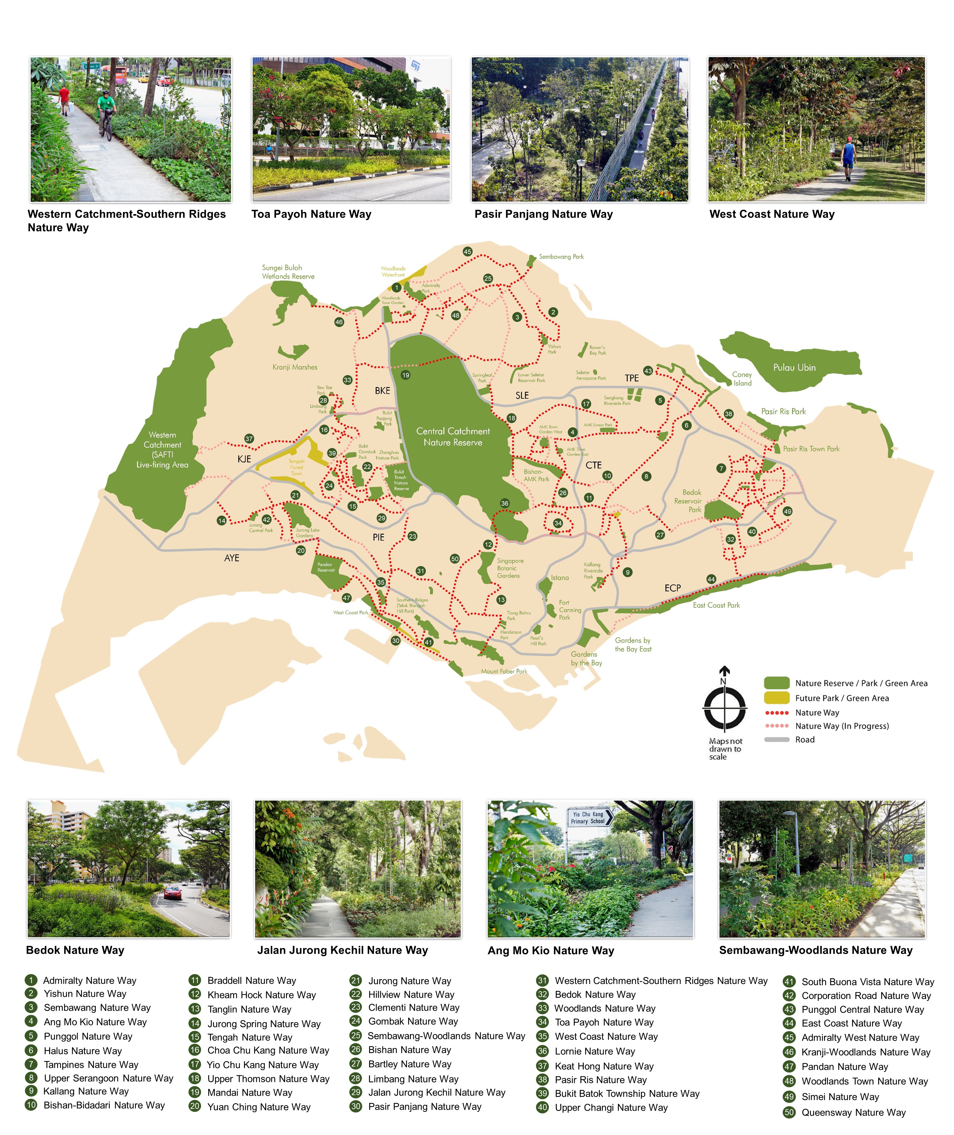
Nature ways are routes planted with specific trees and shrubs that replicate the natural structure of forests. This is to facilitate the movement of animals like birds and butterflies between 2 green spaces and connect areas of rich biodiversity, such as the Western Catchment (SAFTI Live Firing Area), Central Catchment Nature Reserve and Bukit Timah Nature Reserve, to urban communities in order to create a greater appreciation of our City in Nature.

Currently, there are 50 nature ways in Singapore, stretching 210km in total. As part of the Singapore Green Plan 2030 to transform Singapore into a City in Nature, we aim to make every road in Singapore a nature way by having 300km of nature ways.

Read more about our key strategies for a City in Nature by 2030.


How they are developed

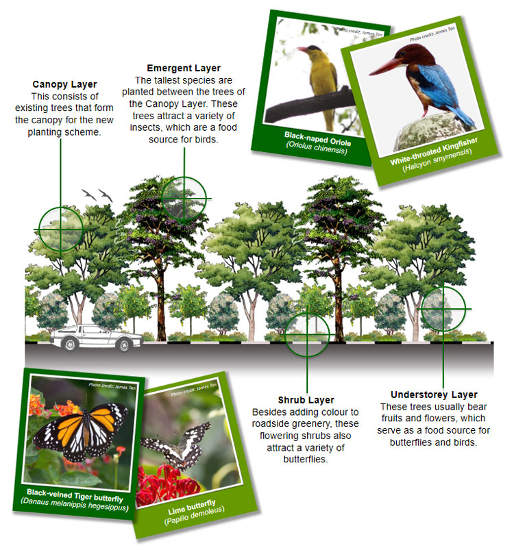
Multi-tiered planting is used to re-create habitats similar to those found in natural forests. This means that plants along nature ways include 4 important layers:

Layer

What it is

Emergent layer

This layer comprises tall species of rainforest trees such as Keruing Pipit, which are planted between the trees of the canopy layer.

When fully matured, these trees attract a variety of insects which provide food for canopy-dwelling birds, and nesting sites for eagles and raptors.

Canopy layer

This layer comprises existing flowering roadside trees such as the Golden Shower Tree and the Trumpet Tree that provide shelter and food for insect-loving as well as nectar-loving birds and butterfly species.

Understorey layer

This layer comprises smaller fruit-bearing trees that produce small berries that are a food source for fruit-loving birds.

Some of these trees are also host plants for butterflies.

Shrub layer

This layer comprises flowering shrubs that provide nectar for butterflies and some nectar-loving birds.

Some of these shrubs are also host plants for various species of butterflies. This layer also provides a habitat for the insects and spiders that birds feed on.

As most of these shrubs are colourful flowering species, and because of the wildlife they attract, this layer also adds colour to roadside greenery.